Da Nang
| Da Nang Thành phố Đà Nẵng |
|
|---|---|
| — Centrally-governed city — | |
 |
|
 |
|
| Coordinates: | |
| Country | |
| Area | |
| - Total | 1,256 km2 (484.9 sq mi) |
| Population (2009 [1]) | |
| - Total | 887,069 |
| - Density | 599/km2 (1,551.4/sq mi) |
| - Ethnicities | Vietnamese, Chinese, Cờ-tu, Tày |
| Time zone | UTC+7 (UTC+7) |
| - Summer (DST) | No DST (UTC+7) |
| Area code(s) | 511 |
| Website | www.danang.gov.vn |
- This article is about the city of Đà Nẵng. For the Vietnam War era air base, see Da Nang Air Base or Da Nang International Airport.
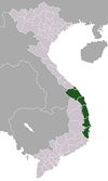
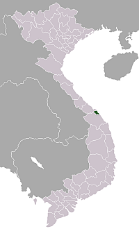
Da Nang (occasionally Danang; in Vietnamese: Đà Nẵng pronunciation) is a major port city in the South Central Coast of Vietnam, on the coast of the South China Sea at the mouth of the Han River. It is the commercial and educational center of Central Vietnam; its well-sheltered, easily accessible port and its location on the path of the North-South Railway also makes it a hub for transportation. It is located within 100 km of several UNESCO World Heritage Sites, including the Imperial City of Huế, the Old Town of Hội An, and the Mỹ Sơn ruins. The city was also known as Tourane or Turon during the French colonization of Vietnam.
Before 1997, the city was part of Quảng Nam-Đà Nẵng province. On January 1, 1997, Đà Nẵng was separated from Quảng Nam province to become one of five independent (centrally-controlled) municipalities in Vietnam. Đà Nẵng is listed as a first class city,[2] and has a higher urbanization ratio than any of Vietnam's other provinces or centrally governed cities.[3]
Contents |
History
The city’s origins date back to the ancient Champa Kingdom, established by Indonesian settlers in 192 AD. Đà Nẵng's name is said to have originated from the Cham word Da Nak, meaning "opening of a big river".[4] At its peak, the Cham’s sphere of influence stretched from Huế to Vũng Tàu. Beginning with Emperor Lê Hoàn (founder of the Early Lê Dynasty), the Vietnamese policy of "southward expansion" (Vietnamese: Nam Tiến) brought Champa increasingly into conflict with their northern neighbours; this expansion evetually led to the decline and fall of the Champa Kingdom during the mid-15th century.
European contact
One of the first Europeans to visit Da Nang was Portuguese explorer Antonio De Faria, who anchored in Da Nang in 1535. De Faria was one of the first Westerners to write about the area, and through his influence Portuguese ships began to call regularly at Hoi An, which was then a much more important port than Da Nang.[5] Throughout the 17th and 18th centuries, French and Spanish traders and missionaries regularly made landfall at Hội An, just south of Đà Nẵng.
Following the edict of Emperor Minh Mạng in 1835 prohibiting European vessels from making landfall or pursuing trade except at Han Port, Da Nang quickly superseded Hội An to became the largest commercial port in the central region.
In 1847, French vessels dispatched by Admiral Cécille bombarded Đà Nẵng, ostensibly on the grounds of persecution of Roman Catholic missionaries.
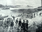
In August 1858, once again ostensibly on the grounds of religious persecution, French troops led by Admiral Charles Rigault de Genouilly, and under the orders of Napoleon III, landed in Da Nang as part of the punitive Cochinchina Campaign. The French overpowered the Vietnamese stationed in Da Nang, swiftly occupying the city and Tien Sa Peninsula (now called Son Tra Peninsula). Despite their initial success, the occupying forces were quickly placed under siege by the Vietnamese army under the command of Nguyen Tri Phuong, and were eventually forced to retreat in March 1860. Conversely, however, the French were able to capture the southern stronghold of Saigon, and in June 1862 several provinces of southern Vietnam were ceded to the French as Cochinchina with the signing of the Treaty of Saigon. Through two more decades of conflict, the French gradually strengthened their hold on Vietnam, culminating in the establishment of French Indochina (French: Union de l'Indochine Française) in October 1887.[6] Two years later in 1889, the French colonists renamed the city Tourane, placing it under the control of the Governor General of Indochina.[7] It came to be considered one of Indochina’s five major cities, among Hanoi, Saigon–Cholon, Haiphong, and Huế.
Vietnam War
During the Vietnam War, the city was home to a major air base that was used by both the South Vietnamese and United States air forces. The base was considered one of the world's busiest airports during the war,[8] reaching an average of 2,595 air traffic operations daily, more than any airport in the world at that time.[9] The final U.S. ground combat operations in Vietnam ceased on 13 August 1972, when a residual force of the 196th Light Infantry Brigade stood down in Đà Nẵng. B Battery 3rd Battalion, 82nd Field Artillery Regiment fired the final U.S. artillery round and the 3rd Battalion, 21st Infantry Regiment finished their final patrols. This residual force was known as "Operation Gimlet".
Geography
Da Nang is the largest city in central Vietnam and one of the country’s most important ports. Ringed by mountains on one side and the South China Sea on the other, Da Nang borders Thua Thien-Hue Province across the Hai Van Pass to the north, Quang Nam Province to the south and west, and the ocean to the east. It is 759 km (472 mi) south of the Vietnamese capital Hanoi, and 960 km (600 mi) north of Ho Chi Minh City.[10]
Geology and topography
Geologically, Da Nang is situated within a Paleozoic fold belt known as the Truong Son Orogenic Zone, whose main deformation occurred during the early Carboniferous period.[11] Da Nang's topography is dominated by the steep Annamite mountain range to the north and northwest, featuring peaks ranging from 700 to 1,500 metres (2,300 to 4,900 ft) in height, and low-lying coastal plains with some salting to the south and east, with several white sand beaches along the coast.[12]
Climate
Da Nang has a tropical monsoon climate with two seasons: a lengthy wet season lasting from May through January and a short dry season lasting from February through April. Temperatures are typically high, with an annual average of 25.9 °C (78.6 °F). Temperatures are highest between June and August (averaging 33 to 34 °C (91 to 93 °F)), and lowest between December and February (averaging 18 to 19 °C (64 to 66 °F)). Short cold spells happen occasionally in winter, bringing even lower temperatures. The annual average for humidity is 83.4%, with highs between October and November (reaching 85–87%) and lows between June and July (reaching 76–77%). On average, Da Nang receives 2,505 mm (98.6 in) of rainfall. Rainfall is typically highest between October and November (ranging from 550 to 1,000 mm (22 to 39 in)) and lowest between January and April (ranging from 23 to 40 mm (0.91 to 1.6 in)). Da Nang receives an average of 2156 hours of sunlight annually, with highs between 234 and 277 hours per month in May and June and lows between 69 and 165 hours per month in November and December.[13]
| Climate data for Da Nang | |||||||||||||
|---|---|---|---|---|---|---|---|---|---|---|---|---|---|
| Month | Jan | Feb | Mar | Apr | May | Jun | Jul | Aug | Sep | Oct | Nov | Dec | Year |
| Average high °C (°F) | 24.8 (76.6) |
26.1 (79) |
28.7 (83.7) |
31.0 (87.8) |
33.4 (92.1) |
33.9 (93) |
34.3 (93.7) |
33.9 (93) |
31.5 (88.7) |
29.6 (85.3) |
27.0 (80.6) |
24.9 (76.8) |
29.93 (85.87) |
| Average low °C (°F) | 18.5 (65.3) |
19.8 (67.6) |
21.5 (70.7) |
23.3 (73.9) |
24.9 (76.8) |
25.5 (77.9) |
25.3 (77.5) |
25.5 (77.9) |
24.1 (75.4) |
23.2 (73.8) |
21.6 (70.9) |
19.3 (66.7) |
22.71 (72.88) |
| Precipitation mm (inches) | 96.2 (3.787) |
33.0 (1.299) |
22.4 (0.882) |
26.9 (1.059) |
62.6 (2.465) |
87.1 (3.429) |
85.6 (3.37) |
103.0 (4.055) |
349.7 (13.768) |
612.8 (24.126) |
366.2 (14.417) |
199.0 (7.835) |
2,044.5 (80.492) |
| Source: World Meteorological Organisation (UN)[14] | |||||||||||||
Demographics
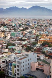
Da Nang is the fifth largest city in Vietnam, with an area of 1,255.53 km² and a population of 887,069 according to the 2009 census.[15] Women make up 50.7% of Da Nang's population. [16]
- Population growth
As of the 2009 census, Da Nang's average annual population growth rate was given as 2.6%, the highest in the North and South Central Coast regions and the sixth highest in the country, behind Binh Duong (with 7.3%), Ho Chi Minh City (3.5%), Kon Tum (3.1%), Binh Phuoc (2.9%), and Gia Lai (2.7%). Da Nang's crude birth rate was recorded at 18.6 live births per 1000 persons; the crude death rate was measured at 6.7 per 1000 persons. Life expectancy at birth was estimated at 77.4 years for women and 72.4 years for men, or 74.8 years overall. The infant mortality rate was measured at 11.0 infant deaths per 1000 live births, less than two points above the nation's average for urban areas. In the same census, the city's immigration and emigration rates were measured at 10.06% and 2.4%, respectively, for a net migration rate of 7.7%.[16] Da Nang's population is estimated to reach one million inhabitants in 2014.[1]
- Urbanization
The city has the highest urbanization ratio among provinces and municipalities in Vietnam,[3] containing only 11 rural communes, the fewest of any province-level unit in Vietnam.[17] As of 2009, 86.9% of Da Nang's population lived in urban areas; average annual urban population growth was 3.5%.[16]
Administration
Administrative divisions
The city is divided into 7 mainland districts and one island district: Cẩm Lệ, Hải Châu, Hòa Vang, Liên Chiểu, Ngũ Hành Sơn, Sơn Trà, Thanh Khê, and Hoàng Sa (Paracel Islands).
Before 1997, the city was part of Quảng Nam-Đà Nẵng province. On January 1, 1997, Đà Nẵng was separated from Quảng Nam province to become one of five independent (centrally-controlled) municipalities in Vietnam.
| District | Area | Population (2007)[18] | Pop. density[18] | ||
|---|---|---|---|---|---|
| (km²) | (mile²) | (persons/km²) | (persons/mile²) | ||
| Cẩm Lệ | 33.3 | 12.9 | 68,320 | 2,054.74 | 5,321.8 |
| Hải Châu | 24.1 | 9.3 | 195,106 | 9,251.11 | 23,960.3 |
| Hòa Vang | 737.5 | 284.8 | 106,910 | 151.14 | 391.5 |
| Liên Chiểu | 83.1 | 32.1 | 95,088 | 1,144.54 | 2,964.3 |
| Ngũ Hành Sơn | 36.5 | 14.1 | 54,066 | 1,476.41 | 3,823.9 |
| Sơn Trà | 60.8 | 23.5 | 119,969 | 1,970.58 | 5,103.8 |
| Thanh Khê | 9.3 | 3.6 | 167,287 | 18,046.06 | 46,739.1 |
| Hoàng Sa | 305 | 118 | 0 | 0 | 0 |
| Total | 1,479.1 | 571.1 | 806,744 | 628.58 | 1,628.0 |
Economy
Da Nang is one of five independent (province-level) municipalities of Vietnam. It is classified as an industrial zone and has port facilities to handle container traffic. Some 4,900 factories/production facilities and a number of light industries are located in the city. In 1997, Đà Nẵng exported around US$55 million worth of goods. Da Nang accounts for a good portion of Vietnam's agricultural food production, including rice, tea, dried fish and fish sauce (nuoc mam). Other goods exported include various types of seafood, furniture, household goods, and clothing.
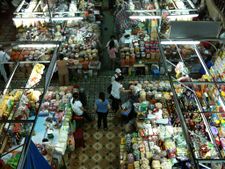
Historically, Da Nang's main marketplace has been Han Market (Vietnamese: Chợ Hàn), which is located downtown near the western bank of the Han River, between Tran Phu and Bach Dang streets. This market, much like Ben Thanh Market in Saigon, offers a wide variety of goods sold by many different vendors, such as clothing, silk, jewelry, flowers, foodstuffs such as dried fruit and fish, coffee, tea and wine (including Vietnamese snake wine), and so on.
Many new construction projects are underway in Da Nang, including several beachfront resorts such as the US$130 million Hyatt Regency Danang Resort & Spa, and the Beach Resort complex (including Ocean Villas and Marriott Hotel) in Ngu Hanh Son District.[19] Another ambitious project, the US$250 million Da Phuoc International New Town undertaken by Korean developer Daewon, aims to construct an entirely new urban area on reclaimed land on the city's north sea coast, making it the first major land reclamation project in Central Vietnam. Plans for the Da Phuoc project include the erection of a hotel and several smaller resorts, a 33-story apartment block and 60-story office block, an 18-hole golf course, a marina, as well as villas and international schools.[20][21]
Tourism
The tourism sector is a vital component of Da Nang's economy. Its status as a transportation hub for Central Vietnam and its proximity to several UNESCO World Heritage Sites, including the Imperial City of Huế, the Old Town of Hội An, and the Mỹ Sơn ruins fuels much of its tourist activity.
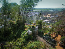
Mỹ Sơn is a remarkable archaeological site dating back more than a thousand years, in Quang Nam Province. Located in a remote forested valley some 70 km west of Đà Nẵng, this former capital and religious center of the Champa kingdom once contained in excess of 70 style temples and stupas. Although badly damaged by bombing raids in the 1960s, the site still has more than 20 structures and was declared a UNESCO World Heritage Site in 1999. Many statues, sculptures and reliefs recovered from Mỹ Sơn are kept in the Museum of Cham Sculpture, near the Han River in the heart of Da Nang. Dating from the fourth to the 14th centuries, the sensual artwork on these works depicts daily activities as well as Hindu and Buddhist religious themes. The museum itself is housed in a beautiful French colonial style villa with open-air courtyards, fruit trees and bougainvillea.
The Marble Mountains are rocky limestone outcrops jutting out of the beach just south of Đà Nẵng. Paths lead to the top of the forested cliffs, affording spectacular views of Non Nuoc Beach and the East Sea. The caves nestled in the cliffs were originally inhabited by the Cham people. Later, Vietnamese under the Nguyễn Dynasty built numerous pagodas amongst the caves. Today, the Marble Mountains are home to various artisans producing sculpture and artwork at its base.
Non Nuoc Beach is a white sandy beach on the outskirts of Đà Nẵng is renowned for both its spectacular beauty and for its history as an R&R destination for American troops during the Vietnam War, when it was known as "China Beach". Today, the beach, along with My Khe beach to the north, are home to expensive resorts, surfing and entertainment facilities.
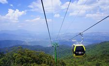
Bà Nà Hills is a mountain resort with a 5 km-long cable car system which carries guests up to Bà Nà's peak at 1487m above sea level. Visitors will enjoy the cool climate at the summit due to the elevation difference.
Son Tra Mount, just some miles away from downtown with some wild streams and resorts along the seaside.
Transportation
Đà Nẵng is on the end of the East-West Economic Corridor (EWEC) which stretches over Vietnam, Laos, Thailand and Myanmar.
By air
Đà Nẵng International Airport, located at the center of the city, is the third international airport in Vietnam. It is an important gateway to access central Vietnam. The airport was known as Da Nang Air Base during the Vietnam War, during which time it was described as the world's busiest airport.[8] During the month of May 1968, the base reached an average of 2,595 air traffic operations daily, more than any airport in the world.[9] The airport has several domestic connections (connecting Hanoi, Hồ Chí Minh City, Quy Nhơn).
By land
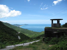
Da Nang is a major station along the North-South Railway, also known as the Reunification Express. National Highways 1A and 14B run through the city, providing road connections to Ha Noi in the north and Ho Chi Minh City in the south, as well as the Central Highlands and Laos to the west. The Hai Van Pass is a mountain pass separating Da Nang and Thua Thien-Hue Province, where Highway 1A road passes through. To cut down on transit time and the danger to motorists from navigating the twisting mountain road, the Hai Van Tunnel was built, opening in 2005. It is the longest tunnel in Southeast Asia at 6.28 km, and allows motorists to save between 30 minutes and an hour on traveling times over the old Hai Van Pass route. An expressway between Da Nang and nearby Quang Ngai is also in the planning stages.
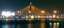
Several bridges cross the Han River and its tributaries in Da Nang, including the iconic Han River Bridge, Tran Thi Ly Bridge, Nguyen Van Troi Bridge, Tuyen Son Bridge and the recently-completed Thuan Phuoc Bridge, which is the longest suspension bridge in Vietnam[22]. The Dragon River Bridge, currently under construction, will cross the Han River at the Le Dinh Duong/Bach Dang roundabout, offering tourists coming from Da Nang International Airport a more direct route to My Khe Beach and Non Nuoc Beach, on the eastern edge of the city.
By sea
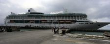
Da Nang's port system is the third largest in Vietnam after Ho Chi Minh City and Hai Phong. In 2008, Da Nang Port handled 2.7 million tons of cargo, of which 1.2 million tons were exports, 525,900 tons were imports, and 985,600 tons were domestic cargo. Over 29,600 passengers passed through the port in 2008, a significant increase over previous years.[23] The port system consists of two areas: Tien Sa Seaport, and Song Han Terminal. Tien Sa Seaport has a navigation depth of 11m, and is able to receive medium range tankers of up to 45,000 DWT, as well as container ships and large cruise ships. The approach to Song Han Terminal is 12 nautical miles long with a navigation depth of 6-7m, and can accommodate vessels of up to 5,000 DWT. Vietnam National Shipping Lines (Vinalines) is the port authority for Da Nang's port system.[23]
Despite the fact that the port's infrastructure is not specifically designed to accommodate cruise ships, the number of large cruise ships docking at Da Nang Port has increased in recent years.[24] In the first two months of 2010 alone, 12 cruise ships docked in Da Nang, carrying 6,477 passengers.[25]
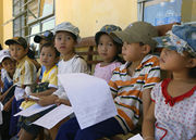
Education
Đà Nẵng has five universities:
- Duy Tân University
- University of Đà Nẵng
- Đà Nẵng University of Architecture
- Đà Nẵng Sports and Physical Exercises University
- Đà Nẵng University of Technology
Đà Nẵng also has more than 10 other colleges, and numerous high schools.
Sports
Ðà Nẵng's football club, SHB Ðà Nẵng F.C., plays in the V-League, Vietnam's top professional football league. They are currently one of the most highly ranked teams in that league, having emerged from competition as champions of the 2009 V-League. In the same year, they were also champions at the Vietnamese Cup playoffs. They also qualified for the 2010 AFC Champions League and the 2010 AFC Cup; although they did not advance past the qualifying play-off in the Champions League,[26] they have advanced to the quarter-finals of the AFC Cup after defeating Becamex Bình Dương in extra time.[27]. Several Ðà Nẵng F.C. players also play on Vietnam's national football team, including defender Võ Hoàng Quảng and midfielder Phan Thanh Hưng. SHB Ðà Nẵng F.C. plays its home games at the Chi Lang Stadium, a 30,000-seat stadium in Hải Châu District. Their manager is Lê Huỳnh Đức.
Sister cities
References
- ↑ 1.0 1.1 "Đà Nẵng có tỷ lệ dân cư đô thị cao nhất nước". http://vietnamnet.vn/xahoi/200910/Da-Nang-co-ty-le-dan-cu-do-thi-cao-nhat-nuoc-876083/.
- ↑ Quyết định số 145/2003/QĐ/TTg ngày 15/7/2003
- ↑ 3.0 3.1 "Đà Nẵng - Trung tâm vùng kinh tế trọng điểm miền Trung"
- ↑ Hỏi đáp về Quảng Nam-Đà Nẵng (Questions and Answers about Quảng Nam-Đà Nẵng) by Bùi Minh Quốc.
- ↑ History of Hội An, a World Heritage Site
- ↑ Peter N. Stearns, ed (2001). The encyclopedia of world history: ancient, medieval, and modern, chronologically arranged. Houghton Mifflin Harcourt. p. 575. ISBN 0395652375. http://books.google.com/books?id=MziRd4ddZz4C&lpg=PA575&ots=Y5bOk8z9qI&pg=PA575#v=onepage&q&f=false.
- ↑ "Danang History". Da Nang People's Committee. 2004-01-03. http://www.danang.gov.vn/TabID/65/CID/704/ItemID//default.aspx. Retrieved 2010-07-09.
- ↑ 8.0 8.1 John Edmund Delezen (2003). Eye of the tiger: memoir of a United States marine, Third Force Recon Company, Vietnam. McFarland. p. 54. ISBN 0786416564. http://books.google.com/books?id=AQ1hqyF1aOAC&lpg=PA54&pg=PA54#v=onepage&f=false. Retrieved 14 July 2010.
- ↑ 9.0 9.1 AACS - Air Communication. Turner Publishing. 2004. ISBN 1563119765. http://books.google.com/books?id=raDlmenz-csC&lpg=PA41&pg=PA41#v=onepage&f=false.
- ↑ Geographic location. Danang People's Committee.
- ↑ Encyclopedia of European and Asian regional geology. Chapman & Hall encyclopedia of earth sciences. 19. Springer. 1997. p. 778. ISBN 0412740400. http://books.google.com/books?id=aYRup5mRcGsC&lpg=PA778&ots=wuWUhegwfi&pg=PA778#v=onepage&f=false. Retrieved 9 August 2010.
- ↑ Topography. Danang People's Committee.
- ↑ Climate. Danang People's Committee.
- ↑ "World Weather Information Service - Da Nang". http://worldweather.wmo.int/082/c00656.htm.
- ↑ Bureau of East Asian and Pacific Affairs (May 27, 2010). "Background Note: Vietnam". U.S. Department of State. http://www.state.gov/r/pa/ei/bgn/4130.htm. Retrieved 2010-06-21.
- ↑ 16.0 16.1 16.2 The 2009 Vietnam Population and Housing census: Major findings. General Statistics Office of Vietnam.
- ↑ The data of local administrative subdivisions till 31/12/2008 by Vietnam Statistics General Office.
- ↑ 18.0 18.1 Danang population. Danang People's Committee.
- ↑ Da Nang: Coastal real estate market bustling
- ↑ US$250-million for Daphuoc International New Town Project In Da Nang City
- ↑ Daewon breaks ground for first urban area on reclaimed land
- ↑ "Vietnam’s longest suspension bridge inaugurated". Danang Investment Promotion Center. 2009-07-23. http://www.vietnamnews.biz/Vietnams-longest-suspension-bridge-inaugurated_570.html. Retrieved 2010-02-19.
- ↑ 23.0 23.1 World Port Source: Da Nang Port
- ↑ Da Nang: more tourists, more worries
- ↑ "Seabourn Odyssey Cruise Ship brings 352 visitors to Danang". Danang.gov.vn. 2010-03-19. http://www.danang.gov.vn/TabID/76/CID/696/ItemID/21034/default.aspx. Retrieved 2010-04-30.
- ↑ "AFC Champions League 2010: Schedule & Results". Asian Football Confederation. http://www.the-afc.com/en/acl-schedule-results?view=Competitions&id=384. Retrieved 2010-06-20.
- ↑ "Da Nang 4-3 Binh Duong. aet". Asian Football Confederation. 2010-05-12. http://www.the-afc.com/en/afc-cup-2010/28866-da-nang-v-binh-duong. Retrieved 2010-06-20.
- ↑ 28.00 28.01 28.02 28.03 28.04 28.05 28.06 28.07 28.08 28.09 28.10 28.11 28.12 28.13 28.14 28.15 "Overseas Relations: Sister cities and prefectures of Danang City". Danang People's Committee. 2007-10-01. http://www.danang.gov.vn/TabID/74/CID/991/ItemID/12084/default.aspx. Retrieved 2010-07-09.
- ↑ Russian and Vietnamesee partnership
External links
- Danang People's Committee
- View Danang city by Virtual Tour 360
- Duy Tan University
- The University of Da Nang
- Danang - Economy
- Ba Na Hills Mountain Resort
- Da Phuoc Newtown
|
||||||||||||||
|
|||||||||||||||||||||
|
||||||||||||||||||||||